نشر مركز "ايسيس" الاميركي للبحوث على شبكة الانترنت صورا التقطتها اقمار صناعية تدعم كما قال الشكوك حيال الانشطة النووية في سوريا ورغبتها في اخفاء موقع مشبوه يمكن ان يكون على صلة بمفاعل قصفته اسرائيل في 2007.
وهذه الصور التقطت اثر طلب قدمته الوكالة الدولية للطاقة الذرية في ايار 2008 للقيام بعمليات تفتيش. وتثبت صور مركز "ايسيس" (معهد العلوم والامن الدولي) حصول نشاط كثيف ووضع اساسات اسمنتية حول موقع مرج السلطان في ضواحي دمشق.
واكد تقرير هذا المركز الذي يتخذ من واشنطن مقرا، ان "حالة تقدم هذا الموقع غير معروفة. لكن يمكن الاشتباه في ان سوريا افرغت هذه المباني قبل منتصف 2008 واتخذت تدابير للتمويه على الانشطة السابقة".
واضاف ان "وضع اساسات جديدة يمكن ان يتطابق مع محاولة لاخفاء العينات البيئية التي كان سيأخذها مفتشو الوكالة الدولية للطاقة الذرية للتحقق مما اذا كان اليورانيوم موجودا خلال زيارتهم لهذه المواقع المشبوهة".
واوضح واضعو هذه التقرير نقلا عن الوكالة الدولية للطاقة الذرية وصحيفة "سودويتشي تسايتونغ" اليومية الالمانية، ان منشأة مرج السلطان التي تضم مصنعا صغيرا لتحويل اليورانيوم، هي احد المواقع الثلاثة "المتصلة بصورة عملانية" مع مفاعل دير الزور الواقع شرق سوريا والذي قصفته اسرائيل في ايلول 2007.
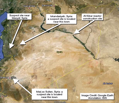
Figure 1. Map of Syria showing the location of the al Kibar reactor and the three sites suspected of being functionally related. The site near Marj as Sultan is located near Damascus.
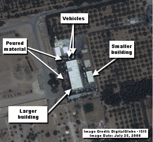
Figure 2: A close-up view of the two main process buildings. Something appears to have been poured on the ground surrounding the larger building. There also appear to be vehicles present which may be involved in this operation. This activity may represent an effort to lay down a new foundation surrounding this building. The IAEA noted in a November 2008 report that it saw in satellite imagery landscaping activities as well the removal of containers shortly after it requested access to these sites in May 2008. Pouring a new foundation may be an effort to defeat IAEA environmental sampling in the event of a visit.
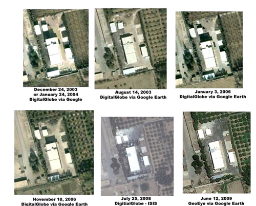
Figure 3. A comparison of the buildings and the surrounding area over the last seven years. The level of activity seen near the larger building in the July 25, 2008 image stands in stark contrast to the other image dates.

Figure 4. Image taken on July 2, 2008 shows the new foundation laid around the buildings.
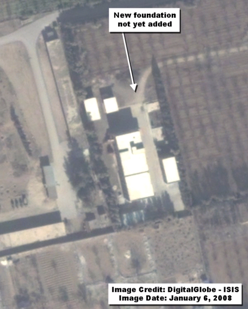
Figure 5. Image from January 6, 2008 shows that the new foundation has not yet been laid around the buildings as of this date. Syria paved the area surrounding the buildings sometime after this image date. Israel bombed the covert reactor construction site in early September 2007.
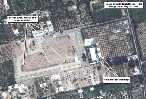
Figure 6. A wider view of the Marj as Sultan site. The main process buildings are seen located at the same site that appears to be a military storage depot. Large guns, trucks, and other vehicles can be seen stored outside
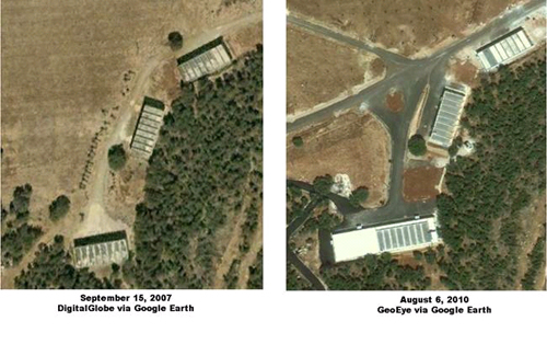
Figure 7. Image of one area of the Masyaf site from two different dates. The image shows a new foundation surrounding what appear to be storage buildings. The IAEA reported in November 2008 that it noticed in satellite imagery landscaping activities at the other suspect sites shortly after it requested to visit in early May 2008. Such landscaping activities could be aimed at defeating environmental sampling that the IAEA may carry out in the event of a visit